
Manufacturer of Airborne LiDAR sensors (ELMAP series) and software for point cloud processing

GeoLas Systems GmbH
Aschau i. ChiemgauNew on Amplifa
About GeoLas Systems
GeoLas Systems GmbH, based in Aschau im Chiemgau, develops and manufactures high-performance airborne LiDAR sensors for aerial laser surveying. The product portfolio includes the compact ELMAP-H scanners for fixed-wing aircraft, helicopters, gyroplanes and large UAVs, the ELMAP-V series for aircraft with small camera hatches and stabilization platforms, and the ELMAP-P pod LiDAR as an integrated turnkey solution for the wing struts of Cessna 172, 182 and 206. The product line also includes the Geocode desktop software (version 5) for processing raw waveform data into geocoded point clouds, including integration of the WavEx software from BayesMap. Building on more than 30 years of experience in the airborne LiDAR field, the company also offers system integration, training and operations support through its sister organization GeoLas Consulting (founded 1999). Customers include surveying companies and integrators such as Phoenix LiDAR Systems, WGS Aerial Surveys and ARSP; fields of application range from wide-area and corridor surveying to agriculture and forestry as well as glacier and coastal monitoring. Deliveries are made worldwide.
- Site
- Aschau i. Chiemgau
- Processes
- Software for point cloud processing (Geocode, incl. BayesMap WavEx integration), Data samples / demo data, System integration, training and operations support via sister organization GeoLas Consulting
- Materials
- ELMAP-H Airborne LiDAR, ELMAP-V Airborne LiDAR, ELMAP-P Pod LiDAR, Geocode Software (Version 5)
- Certificates
- Manufacturer support and training
- Founded
- 2019
- Industries
- Surveying / Airborne Laser Mapping, Agriculture, Forestry, Mining, Infrastructure / Corridors, Coastal Engineering
- 01
Development and manufacturing of the ELMAP LiDAR sensors
- 02
Geocode software for point cloud processing (standard scope of delivery)
- 03
System integration and installation
- 04
Training and operations support (GeoLas Consulting)
- 05
Worldwide sales and support
Products & Technologies
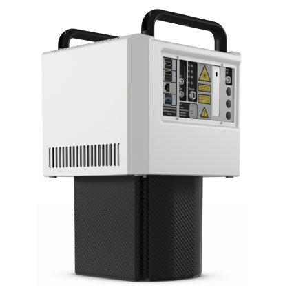
ELMAP-H Airborne LiDAR
Compact high-performance laser scanners for cost-efficient aerial surveying with fixed-wing aircraft, helicopters, gyroplanes and large UAVs.
ELMAP-V Airborne LiDAR
High-performance laser scanners specially designed for installation in aircraft with small camera hatches and in stabilization platforms.
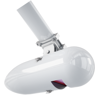
ELMAP-P Pod LiDAR
Special version for the wing struts of Cessna 172/182/206, fully integrated with ELMAP LiDAR and GNSS/IMU as a turnkey solution.
Geocode Software (Version 5)
Desktop application for converting raw waveform data into geocoded point clouds, with integration of BayesMap WavEx for range disambiguation and parallel processing.
Locations
Aschau i. Chiemgau
DEHeadquarters, development and manufacturing
- Materials
- Airborne LiDAR hardware, software
- ELMAP-H laser scanner
- ELMAP-V laser scanner
- ELMAP-P pod LiDAR
- Geocode software (version 5)
Products

Inside the production







Industries
4 Anlagen & Maschinen
| Machine | Manufacturer / model | Quantity | Working area | Year built | Site |
|---|---|---|---|---|---|
| Airborne LiDAR laser scanner | GeoLas Systems ELMAP-H | – | – | – | Aschau i. Chiemgau, Germany |
| Airborne LiDAR laser scanner | GeoLas Systems ELMAP-V | – | – | – | Aschau i. Chiemgau, Germany |
| Airborne pod LiDAR | GeoLas Systems ELMAP-P | – | – | – | Aschau i. Chiemgau, Germany |
| Software for point cloud processing | GeoLas Systems Geocode (Version 5) | – | – | – | Aschau i. Chiemgau, Germany |
Additional services
Reference customers
Quality
Product quality is demonstrated by more than 30 years of experience in the airborne LiDAR field and by long-term customer use across multiple sensor generations since 2013. System integration, training and operations support complement the products through the sister organization GeoLas Consulting.
| Evidence | Aschau i. Chiemgau |
|---|---|
| Manufacturer support and training |
History
- 1999
Founding of sister organization GeoLas Consulting
- 2019
Founding of GeoLas Systems GmbH